
Файл:Sahel Map-Africa rough.png
Барам хьажале: 800 × 370 пиксель. Кхин шоралла: 320 × 148 пиксель | 640 × 296 пиксель | 1024 × 474 пиксель | 2000 × 925 пиксель.
Оригиналан файл (2000 × 925 пиксель, файлан барам: 291 Кб, MIME-тайп: image/png)
| Цуьнах лаьцна |
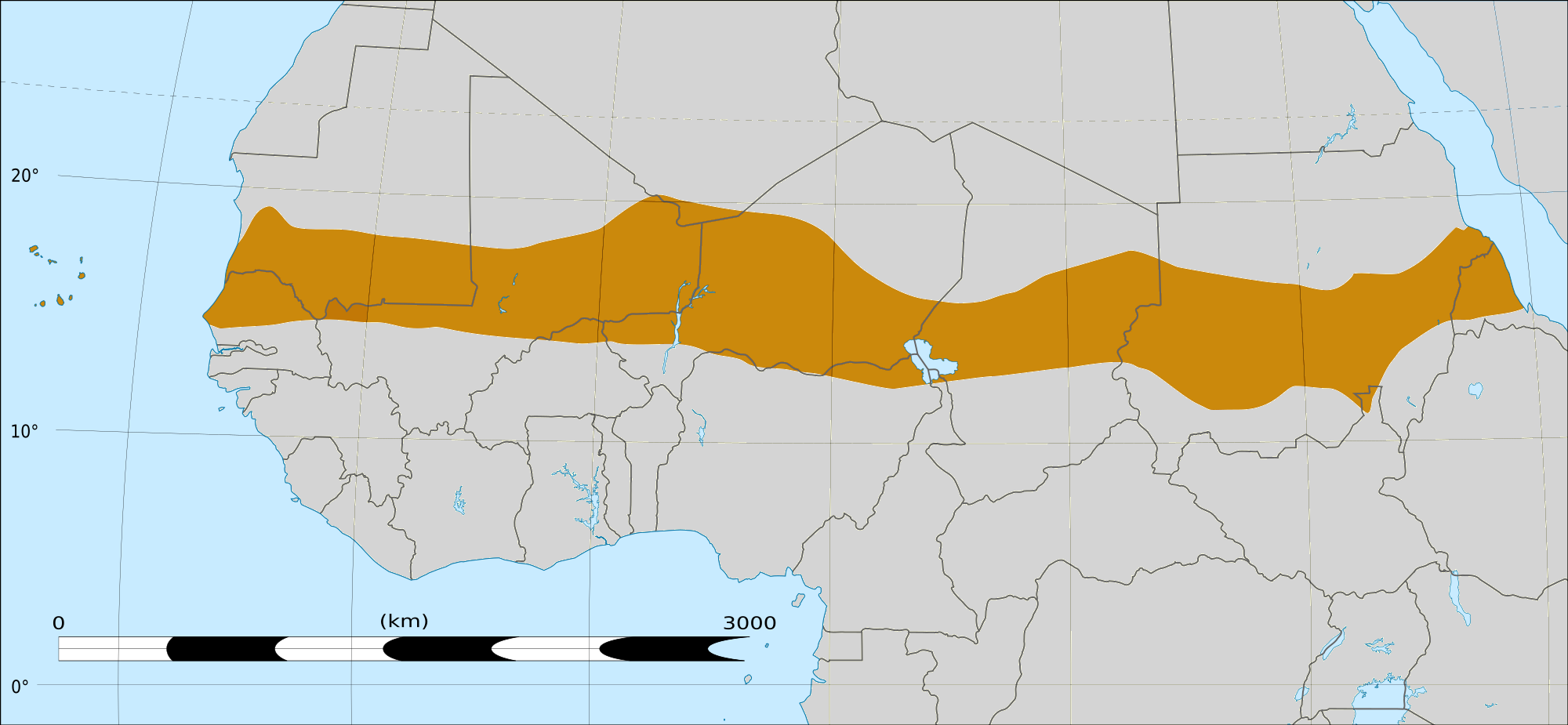
English: Map of Africa, with the Sahel highlighted in orange.
This is roughly the African land area between the lines of 200mm (north) and 600mm (south) mean 20th century annual rainfall. This is limited to land areas directly to the south of the Sahara desert and including the islands of Cape Verde, but not including other areas in Africa with the same rainfall statistics. This is one, but not the only, definition of the Sahel region. |
|||
| Терахь | шeран 20 февраль 03:54 (UTC) | |||
| Хьост |
Felix Koenig: "created/photographed by myself (based on the existing blank map of Africa)"
|
|||
| Автор | ||||
| Кхин версеш |
|


| Это отретушированное изображение, что означает, что первоначальной версия изображения была изменена цифровым способом. Изменения: Reproduced Sahel boundary from Map sahel.jpg on png map, cropped. Оригинал доступен по ссылке: BlankMap-Africa2.png:
|
Лицензи
Аса хӀокху произведенин авторо, сай лаамца йаржайо и хӀокху лицензица:

|
Магадо хӀара документ копеш йан, йаржо йа хийца а хӀокху GNU Free Documentation License лицензица верси 1.2 йа цул хьалхарниг, маьрша программа латточу фондас арахецна, хийца цалуш долу дакъошца, йоза доцуш, цхьалхачу а, тӀаьхьарчу а мужалтан тӀехь. Лицензин копи йу дакъа чохь GNU Free Documentation License. |
This file is licensed under the Creative Commons Attribution-Share Alike Attribution-Share Alike 4.0 International, 3.0 Unported, 2.5 Generic, 2.0 Generic and 1.0 Generic license.
- Хьа йиш йу маьрша:
- произведени йаржо – копи йан, йаржо а, хӀара произведи дӀасайекъа а.
- арахецарш кхолла – хӀара произведени дӀасайекъа
- Лахара хьолаца лело мега:
- авторш билгалбар – Ахьа авторш билгалбан беза (хьост) кхин авторо йа лицензи хӀотточо билгалйина бакъо (амма авторо ахьа дешдерг кхобалдина санна ма-хилийта).
- йаржа йан мега оцу хьолаца – Хьайна хӀара хийца йа хӀокхунах кхин произведени кхолла лууш делахь, хьа йиш йу хилла произведени хӀокху йа цуьнца йогӀуш йолу лицензица йаржо.
Хьан аьтту бу лицензийн йукъара муьлха цхьаъ харжа.
|
|
Магадо хӀара документ копеш йан, йаржо йа хийца а хӀокху GNU Free Documentation License лицензица верси 1.2 йа цул хьалхарниг, маьрша программа латточу фондас арахецна, хийца цалуш долу дакъошца, йоза доцуш, цхьалхачу а, тӀаьхьарчу а мужалтан тӀехь. Лицензин копи йу дакъа чохь GNU Free Documentation License. |
Чуйахаран дӀадолалун тептар
This image is a derivative work of the following images:
- File:Map_sahel.jpg licensed with GFDL
- 2005-05-30T17:36:46Z King 800x800 (89588 Bytes) one moment please
- File:BlankMap-Africa2.png licensed with Cc-by-sa-3.0,2.5,2.0,1.0, GFDL
- 2008-03-08T18:02:20Z Sadalmelik 1754x1546 (51013 Bytes) {{Information |Description=Blank map of Africa |Source=self-made |Date=2008-03-08 |Author= [[User:Sadalmelik|Sadalmelik]] |Permission= |other_versions= }} [[Category:Blank maps of Africa]]
Uploaded with derivativeFX
Файлан истори
Тlетаlаде терахь/хан, муха хилла хьажарна и файл.
| Терахь/Хан | Жима | Файлан барам | Декъашхо | Билгалдаккхар | |
|---|---|---|---|---|---|
| карара | 2018, 17 март, 16:15 | | 2000 × 925 (291 Кб) | Maphobbyist | South Sudan border |
| 2009, 20 февраль, 04:02 |  | 1384 × 658 (29 Кб) | T L Miles | {{Information |Description=*Description: A map of Africa: the Sahel highlighted in orange. Note, this is ROUGHLY the African land area between the lines of 200mm (north) and 600mm (south) mean 20th century annual rainfall. This is limited to land areas d |
Файл лелор
ХӀара файл лахарчу 2 агӀонгахь лелош йу:
Глобалан файл лелор
ХӀара файл лелош йу лахахь гайтина йолу википедеш чохь:
- Лелор af.wikipedia.org
- Лелор als.wikipedia.org
- Лелор ar.wikipedia.org
- Лелор az.wikipedia.org
- Лелор bcl.wikipedia.org
- Лелор be.wikipedia.org
- Лелор bg.wikipedia.org
- Лелор bn.wikipedia.org
- Лелор br.wikipedia.org
- Лелор ca.wikipedia.org
- Лелор da.wikipedia.org
- Лелор en.wikipedia.org
- Лелор eu.wikipedia.org
- Лелор fa.wikipedia.org
- Лелор fi.wiktionary.org
- Лелор fr.wikipedia.org
- Лелор fr.wikinews.org
- Лелор ha.wikipedia.org
- Лелор ig.wikipedia.org
- Лелор incubator.wikimedia.org
- Лелор it.wikipedia.org
- Лелор ja.wikipedia.org
- Лелор ka.wikipedia.org
- Лелор ko.wikipedia.org
- Лелор mg.wikipedia.org
- Лелор mk.wikipedia.org
- Лелор ml.wikipedia.org
- Лелор mr.wikipedia.org
Хьажа хӀара файл глобалан лелор.