
Файл:Prussian clans 13th century.png

Оригиналан файл (900 × 634 пиксель, файлан барам: 353 Кб, MIME-тайп: image/png)
Файлах лаьцна
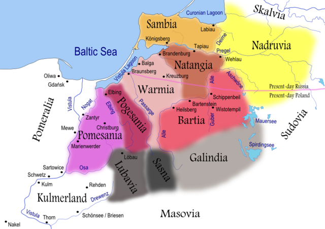
| Цуьнах лаьцна | Map of Prussian clans during the 13th century. Areas shaded in grey reached further south than shown on this map. Prussian clans of Galindians, Sudovians, Sasna and Lubavia as well as Kulmerland had become subjected to numerous incursions and conquests by recently arriving Slavs. |
| Терахь | |
| Хьост | Self-made using Inkscape (see below for full discussion) |
| Автор | Renata3 |
| Кхин версеш |
|
For background I used: Image:LithuaniaPhysicalMap-Clean.svg by user:Knutux. For consistency, German names were used for cities/castles, rivers and lakes. Tribes/clans were named by their most common English names. Note that all boundaries (including rivers and lakes) are approximate. Shoreline was depicted as it is today (it has changed significantly from the 13th century).
Sources:
- Main: Map used to illustrate article on Prussians in Encyclopedia Lithuanica, volume IV, page 367. It generally agrees with Map by Marija Gimbutas published in The Balts (1963).
- Other: Map from National Museum of Lithuania and maps presented in William Urban (2000). The Prussian Crusade, ISBN 0-929700-28-7
A quite different map is presented in Bojtár, Endre (1999). Foreword to the Past: A Cultural History of the Baltic People. CEU Press, 159. ISBN 963-9116-42-4
Лицензи

|
Магадо хӀара документ копеш йан, йаржо йа хийца а хӀокху GNU Free Documentation License лицензица верси 1.2 йа цул хьалхарниг, маьрша программа латточу фондас арахецна, хийца цалуш долу дакъошца, йоза доцуш, цхьалхачу а, тӀаьхьарчу а мужалтан тӀехь. Лицензин копи йу дакъа чохь GNU Free Documentation License. |
| ХӀара файл лело йиш йу Creative Commons Attribution-Share Alike 3.0 Unported лицензица. | ||
| Авторан цӀе дӀайазйар: I, Renata3 | ||
| ||
| ХӀара лицензи йар файлан тӀетоьхна лицензи карлайаккхаран GFDL дакъа санна. |
- Хьа йиш йу маьрша:
- произведени йаржо – копи йан, йаржо а, хӀара произведи дӀасайекъа а.
- арахецарш кхолла – хӀара произведени дӀасайекъа
- Лахара хьолаца лело мега:
- авторш билгалбар – Ахьа авторш билгалбан беза (хьост) кхин авторо йа лицензи хӀотточо билгалйина бакъо (амма авторо ахьа дешдерг кхобалдина санна ма-хилийта).
- йаржа йан мега оцу хьолаца – Хьайна хӀара хийца йа хӀокхунах кхин произведени кхолла лууш делахь, хьа йиш йу хилла произведени хӀокху йа цуьнца йогӀуш йолу лицензица йаржо.
Файлан истори
Тlетаlаде терахь/хан, муха хилла хьажарна и файл.
| Терахь/Хан | Жима | Файлан барам | Декъашхо | Билгалдаккхар | |
|---|---|---|---|---|---|
| карара | 2008, 6 апрель, 20:38 | | 900 × 634 (353 Кб) | Renata3 | resolution |
| 2008, 6 апрель, 20:35 |  | 529 × 372 (159 Кб) | Renata3 | masovia | |
| 2007, 15 июль, 22:55 |  | 991 × 713 (399 Кб) | Renata3 | change colors and name for Sasna | |
| 2007, 14 июль, 18:34 |  | 1012 × 728 (412 Кб) | Renata3 | er... reduce size | |
| 2007, 14 июль, 18:31 |  | 2029 × 1455 (1,08 Мб) | Renata3 | add more river names, insculde Sassen | |
| 2007, 11 июнь, 00:43 |  | 989 × 722 (387 Кб) | Renata3 | {{Information |Description=Map of Prussian clans during the 13th century |Source=Self-made using Inkscape |Date=2007-07-10 |Author= Renata3 }} For background I used: Image:LithuaniaPhysicalMap-Clean.svg by user:Knutux. Sources |
Файл лелор
ХӀара файл лахарчу 1 агӀонгахь лелош йу:
Глобалан файл лелор
ХӀара файл лелош йу лахахь гайтина йолу википедеш чохь:
- Лелор an.wikipedia.org
- Лелор ar.wikipedia.org
- Лелор bat-smg.wikipedia.org
- Лелор ba.wikipedia.org
- Лелор be-tarask.wikipedia.org
- Лелор be.wikipedia.org
- Лелор bg.wikipedia.org
- Лелор ca.wikipedia.org
- Лелор csb.wikipedia.org
- Лелор cs.wikipedia.org
- Лелор da.wikipedia.org
- Лелор dsb.wikipedia.org
- Лелор el.wikipedia.org
- Лелор en.wikipedia.org
Хьажа хӀара файл глобалан лелор.