
Файл:Arunachal Pradesh in India.png
Arunachal_Pradesh_in_India.png (350 × 425 пиксель, файлан барам: 80 Кб, MIME-тайп: image/png)
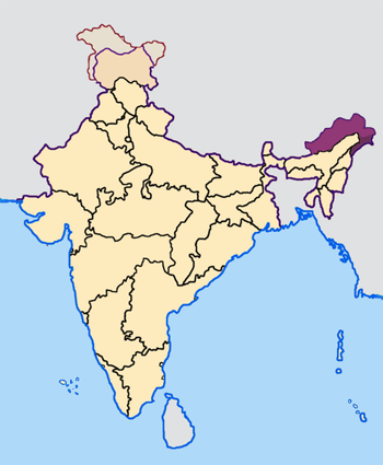
Map made by me, Nichalp
Note: The Indian state of w:Arunachal Pradesh is claimed by China as a part of w:South Tibet. The claimed region is shown in a different colour.
The Indian state of w:Jammu and Kashmir is claimed by w:India, w:Pakistan and the w:People's Republic of China. This map depicts the boundaries of the state as it was in 1947. Areas administered by India is coloured as per the rest of the states, and the area administered by Pakistan and China are coloured in a neutral colour. See the map of Jammu and Kashmir.
See the map of Arunachal Pradesh.
The Indian territorial waters extend to a distance of twelve nautical miles.

|
Магадо хӀара документ копеш йан, йаржо йа хийца а хӀокху GNU Free Documentation License лицензица верси 1.2 йа цул хьалхарниг, маьрша программа латточу фондас арахецна, хийца цалуш долу дакъошца, йоза доцуш, цхьалхачу а, тӀаьхьарчу а мужалтан тӀехь. Лицензин копи йу дакъа чохь GNU Free Documentation License. |
| ХӀара файл лело йиш йу Creative Commons Attribution-Share Alike 3.0 Unported лицензица. | ||
| ||
| ХӀара лицензи йар файлан тӀетоьхна лицензи карлайаккхаран GFDL дакъа санна. |
Файлан истори
Тlетаlаде терахь/хан, муха хилла хьажарна и файл.
| Терахь/Хан | Жима | Файлан барам | Декъашхо | Билгалдаккхар | |
|---|---|---|---|---|---|
| карара | 2005, 23 апрель, 07:27 | | 350 × 425 (80 Кб) | Nichalp | NPOV map |
| 2005, 23 апрель, 07:21 |  | 200 × 231 (22 Кб) | Kerpal | Reverted to earlier revision | |
| 2005, 23 апрель, 06:13 |  | 650 × 790 (126 Кб) | Nichalp | Reverted to earlier revision | |
| 2005, 23 апрель, 04:59 |  | 200 × 231 (22 Кб) | Kerpal | Reverted to earlier revision | |
| 2005, 23 апрель, 04:50 |  | 650 × 790 (126 Кб) | Nichalp | Reverted to earlier revision | |
| 2005, 22 апрель, 21:04 |  | 200 × 231 (22 Кб) | Kerpal | Reverted to earlier revision | |
| 2005, 22 апрель, 13:32 |  | 650 × 790 (126 Кб) | Nichalp | Reverted to earlier revision | |
| 2005, 22 апрель, 09:55 |  | 200 × 231 (22 Кб) | Kerpal | originally by en:User:Morwen | |
| 2005, 21 апрель, 17:47 |  | 650 × 790 (126 Кб) | Nichalp | Map made by me, ~~~ Note: The Indian state of w:Jammu and Kashmir is claimed by w:India, w:Pakistan and the [w:People's Republic of China]]. This map depicts the boundaries of the state as it was in 1947. Areas administered by India is colou |
Файл лелор
ХӀара файл агӀонашкахь лелош йац.
Глобалан файл лелор
ХӀара файл лелош йу лахахь гайтина йолу википедеш чохь:
- Лелор bxr.wikipedia.org
- Лелор de.wikipedia.org
- Лелор en.wikipedia.org
- Лелор fi.wikipedia.org
- Лелор ka.wikipedia.org
- Лелор mr.wikipedia.org
- Лелор ta.wikipedia.org
- Лелор te.wikipedia.org
- Лелор xmf.wikipedia.org